 © Google Maps
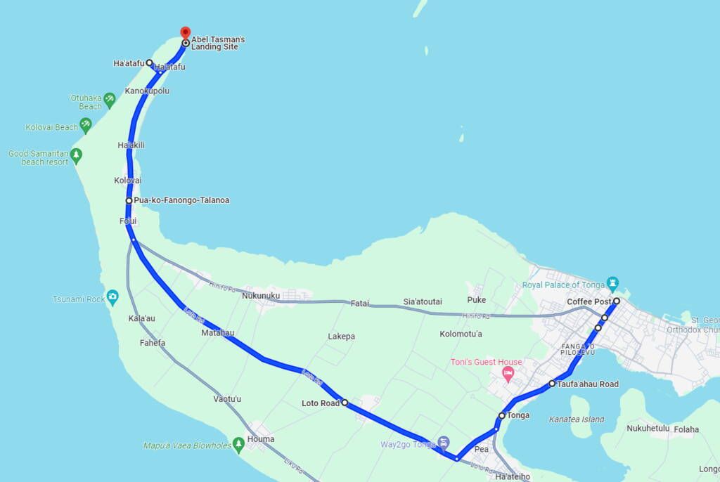
Nuku’alofa to Abel Tasman’s Landing Site
Distance: 26 km (16.2 mi), Drive time: 45 mins.
Tonga Culture Centre and King’s Residence
As most accommodations on Tongatapu are based in Nuku’alofa, we are starting this itinerary from the capital. We have some city exploration for you in A Self-Guided Walking Tour of Nuku’alofa: One Day Itinerary which takes around two hours. Otherwise, head south on Nuku’alofa’s main road, Taufa’ahau Road.
As you reach the suburb of Tofoa, approximately 3 km (1.8 mi) from the city centre, look out for the traditionally inspired fale architecture of Tonga Culture Centre on the waterfront, which is now the location of Tonga’s new Parliament Buildings after the one in Nuku’alofa was destroyed during Cyclone Gita in 2018. Across the road is Vaiola Hospital, the main hospital in Tonga.
Approximately 1.8 km (1.1 mi) further past the Culture Centre, you’ll notice an elaborate gateway with a pristine driveway leading to a red-roofed mansion atop the hill. This is the King’s Residence and where the Royal Family live. It is not open to the public.
Three-Headed Coconut Tree
The next village is Pea and the imposing Costlow Supermarket which, although is physically the largest supermarket in Tonga, is a commercial flop with mostly bare shelves.
At least the fast-food takeaway next door offers cheap eats of Philly cheese steaks for the road – see The Top Cheap Eats in Nuku’alofa & Tongatapu. The supermarket is also a good indicator to turn right and follow the road inland.
When you reach the major intersection, turn right onto Loto Road. Continue on Loto Road for approximately 3.1 km (1.9 mi) where you’ll notice the magnificent white architecture of the Nuku’alofa Tonga Temple (Temple of the Latter-Day Saints) on your right.
Just a little further along is the Three-Headed Coconut Tree signposted at the western end of Liahona village. The quirky attraction is visible from the road with not much room for parking, so pull off the road as much as possible (without falling down a ditch) to take your photos.
It’s a bit of a longer drive to your next attraction (around 9.4 km/5.8 mi), where you’ll pass through the villages of Matahau and then Fou’ui as the road merges onto Hihifo Road.
 © TongaPocketGuide.com
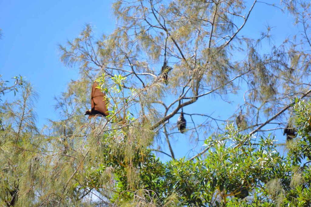
Flying Foxes of Kolovai
As you reach the village of Kolovai, pull over in a safe place occasionally and look up toward the trees to see Kolovai’s large population of flying foxes (peka). Generally, outside of the churches are good places to stop. Flying foxes thrive in Tonga because they are considered the property of the Royal Family, therefore it is illegal to hunt them.
Ha’atafu Beach
The next area to explore, around the village of Kanokupolu, was one of the worst affected during the 2022 Hunga-Tonga Hung-Ha’apai Volcanic Eruption which sent tsunami waves across the beach and villages.
Nevertheless, the locals have brought beauty back to the area, especially with an endearing walkway leading to Ha’atafu Beach, whose main entrance is the final road on the left leading to the coast.
The beach is also good for swimming and surfing, as listed in the 25 Best Beaches on Tongatapu.
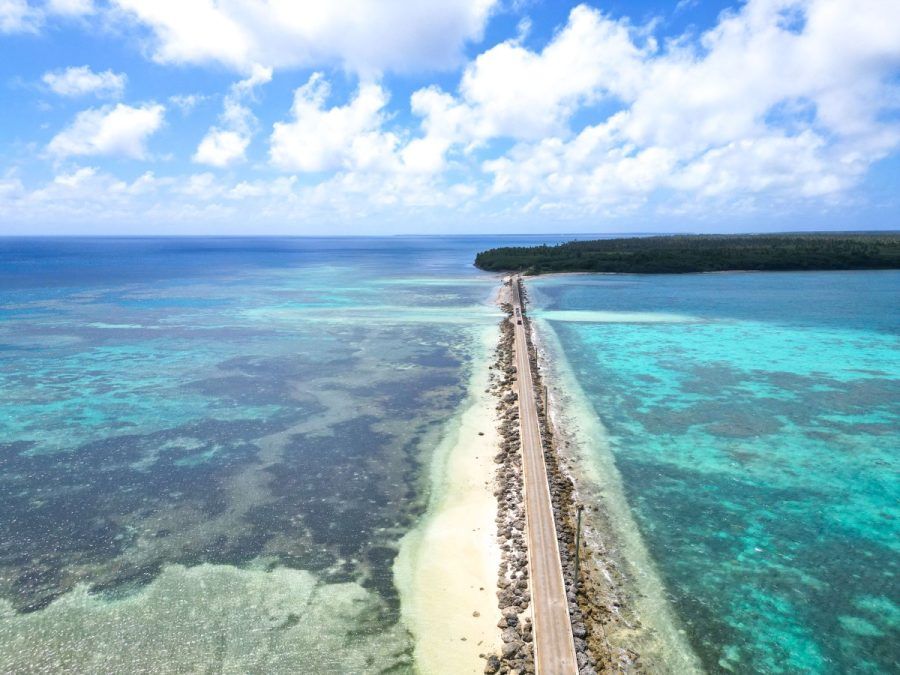
Abel Tasman’s Landing Site
Return to Hihifo Road and follow it north all the way to the end, where you’ll find a plaque memorial commemorating the Landing Site of Abel Tasman, attributed to be one of the first Europeans to “discover” Tonga. The plaque itself is no longer accessible, although you can look at it forlornly through the wire fence.
Nevertheless, the area still offers beautiful views, with a lookout facing Tongatapu’s lagoon and outer islands at the end of the road.
 © Google Maps
Abel Tasman’s Landing Site to Hufangalupe Landbridge
Distance: 31.5 km (19.5 mi), Drive time: 1 hr.
Christianity Landing Site
After soaking in the views from Abel Tasman’s Landing Site, head back south for approximately 140 m (150 yards) and look out for an opening on your left.
In the middle of a grassy area is another plaque memorial of the “Christianity Landing Site“, which tells the story, in English on one side and Tongan on the other, of how the pioneering missionaries, Rev. John Thomas and Rev. John Hutchinson, introduced Christianity to Tonga.
On your way back, look out for signs for Cafe Baraka, open Thursday, Friday and Saturday mornings, serving cafe food like sandwiches.
Tsunami Rock
Continue south on Hihifo Road through the villages you already travelled through (look out for the flying foxes if you missed them the first time) until you reach a three-way split in the road. Head south on Liku Road and follow it for around 2.4 km (1.5 mi) where the Tsunami Rock will be signposted at a turn-off toward the coast.
Take the dirt road right, just before reaching the end of the road. If it’s too boggy, you can walk the rest of the way to Tsunami Rock, a 9 m (29 ft)-high boulder that is believed to have been washed up onto shore during a tsunami.
Mapua ‘a Vaea Blowholes
Next on the agenda is the Mapua ‘a Vaea Blowholes! Head back onto Liku Road and continue east through Vaotu’u village until you reach the large village of Houma.
Just after the Latter-Day Saints Church, the blowholes are signposted right towards the coast. Follow this road all the way to the coast where you’ll reach a large parking area with platforms and seats to make yourself comfortable as you watch the show of blowholes shooting the swell into the air and tumbling onto the tiered reef below. It’s quite the spectacle of nature!
 © TongaPocketGuide.com
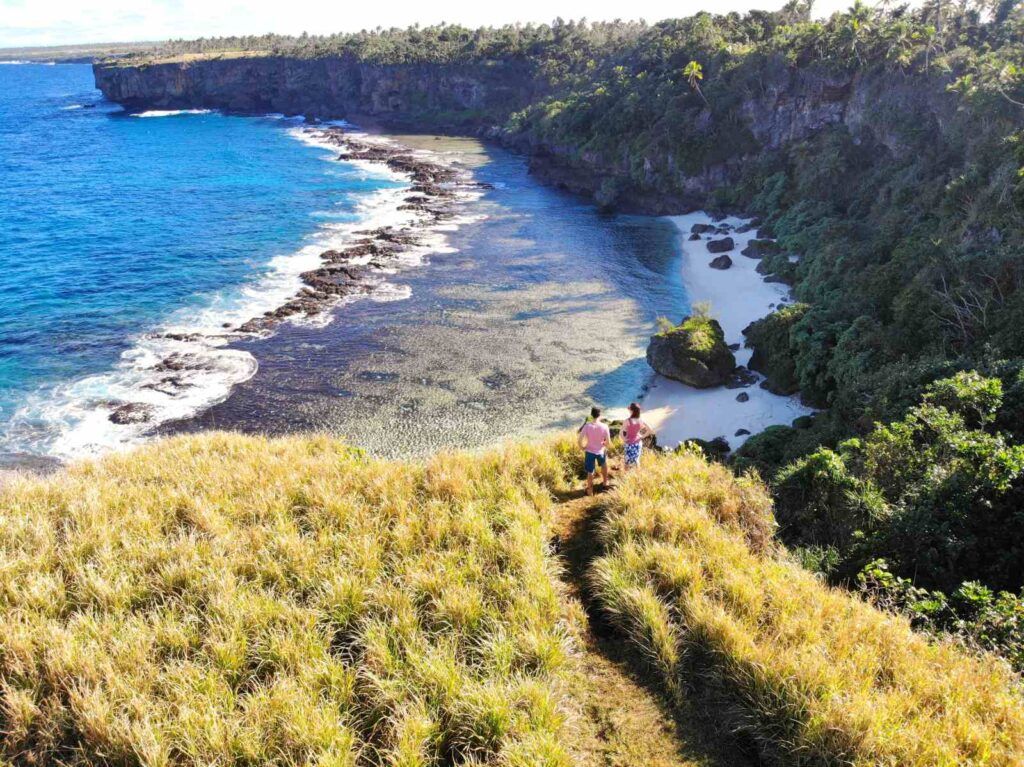
Hufangalupe Landbridge, Cliffs and Beach
Once you manage to pull yourself away from the blowhole show, head back on Liku Road and continue east. There are many beach access roads along this south coast, with highlights including Keleti Beach, which you can learn more about in the 25 Best Beaches on Tongatapu. However, you’ll likely struggle to fit more beach visits into one day.
After passing through ‘Utulau village, you’ll find this stretch of the south coast is pretty peaceful as you travel past acres and acres of plantations. It’s not until around 14 km (8.9 mi) after leaving Houma that you’ll come across the crossroads for Hufangalupe Road and Hufangalupe Beach and Lookout signposted right toward the coast.
This road is in the worst condition on this itinerary, so go as far as you are comfortable with and where you can safely park on the side and walk the rest of the way. Notice some established trails to your right to reach a scenic viewpoint of Hufangalupe Beach.
From the viewpoint, return to the dirt road and walk approximately 170 m (186 yards) south until you reach another established walking trail through the grass on your left. Here is a viewpoint of the Hufangalupe Landbridge where you’ll see the ocean right through the archway.
You can return to the dirt road/trail and walk over the Landbridge and along the clifftop for around 100 m (109 yards) and look back to get wonderful views of the dramatic cliffs and coastline.
 © Google Maps
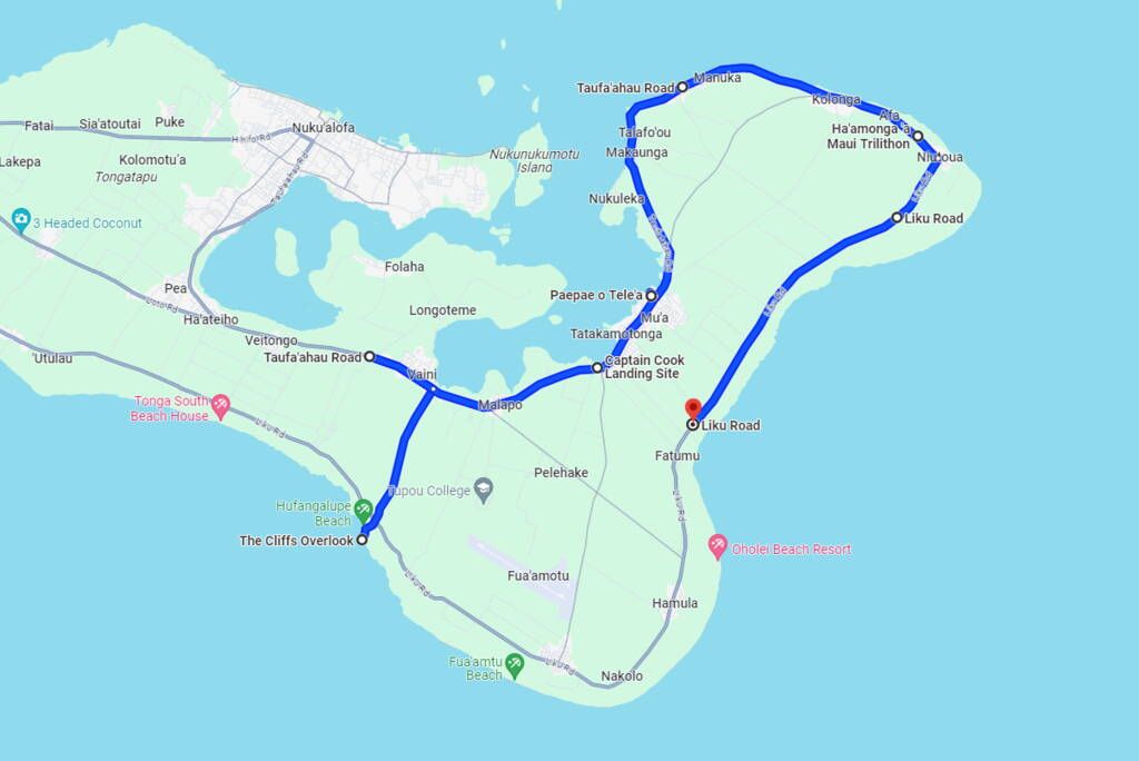
Hufangalupe Landbridge to ‘Anahulu Cave
Distance: 40 km (25 mi), Drive time: 1 hr 15 mins.
Lunch in Vaini
After you are done exploring Hufangalupe, take the dirt road back to Liku Road where you’ll carry straight on across the crossroads along Hufangalupe Road toward Vaini village.
You have a few lunch stops in and around Vaini, see 10 Best Cafes in Nuku’alofa & Tongatapu), and the Tongan restaurants of Keli’i and Rose Restaurant and ‘Ofeina Restaurant which are a little further west – see The Top Cheap Eats in Nuku’alofa & Tongatapu.
On the way to the Terraced Tombs, you will pass Mahalo’s Home Baked Goodness, one of the few café-style spots outside Nuku’alofa. This Lapaha bakery serves freshly made sweets daily, from cheesecakes to pineapple pies, alongside ice cream and waffles, perfect for a sweet break during your day trip.
 © TongaPocketGuide.com
Captain Cook’s Landing Site and the Terraced Tombs
Once you’re well fed, head back east along Taufa’ahau Road until you see Captain Cook’s Landing Site signposted on the left side just before reaching the village of Mu’a. A plaque is in the place where a banyan tree once stood to commemorate the event that took place in 1777. You’ll also get interesting views of the Fanga’utu Lagoon.
As you travel further north on Taufa’ahau Road through the village of Lapaha, you’ll notice brown tourist attraction signs pointing to various “Terraced Tombs” where much of Tonga’s royalty were buried during the 16th Century.
There are around 28 pyramid-like tombs in total, but a highlight is the Paepae ‘o Tele’a Tombs signposted on the coastal side of Taufa’ahau Road.
Taufa’ahau Road continues north along the coast, taking you through a number of picturesque seaview villages including Makaunga, Talafo’ou and then Navutoka, the latter famous for its “Fishing Pigs“. Stop along the coast to watch pigs sticking their heads into the watery mudflats in search of food.
Ha’amonga ‘a Maui
More peaceful yet scenic villages lie along the north coast of Tongatapu as you continue your way toward, what many consider a highlight of Tongatapu sightseeing, the Ha’amonga ‘a Maui! Easy to spot at the western end of Niutoua village, Ha’amonga ‘a Maui is a megalithic structure built in the 13th Century.
Behind the arch monument, you can also check out Maka Fa’akinanga, a leaning stone pillar which is said to be where the King of Tonga at the time rested while watching the construction of the Ha’amonga. Browse the souvenir stalls here, then get back on the road continuing east through Niutoua.
‘Anahulu Cave and Beach
The grand finale of this one-day itinerary of Tongatapu awaits down Liku Road. Follow it south for around 10 km (6 mi) until you reach signposts for ‘Anahulu Cave in Haveluliku village. There are bathrooms here if you need them.
Get changed into your swimmers (and cover them with shorts/T-shirt/sarong to respect the local customs), pay your entry fee, and make your way down the steps either to ‘Anahulu Beach first or straight into the magnificent limestone cave where a walkway takes you to a freshwater swimming pool.
That’s it for our one-day Tongatapu itinerary! If you want to return to Nuku’alofa, add 21 km (35 mins) to your driving distance.